Samikhsya Bureau
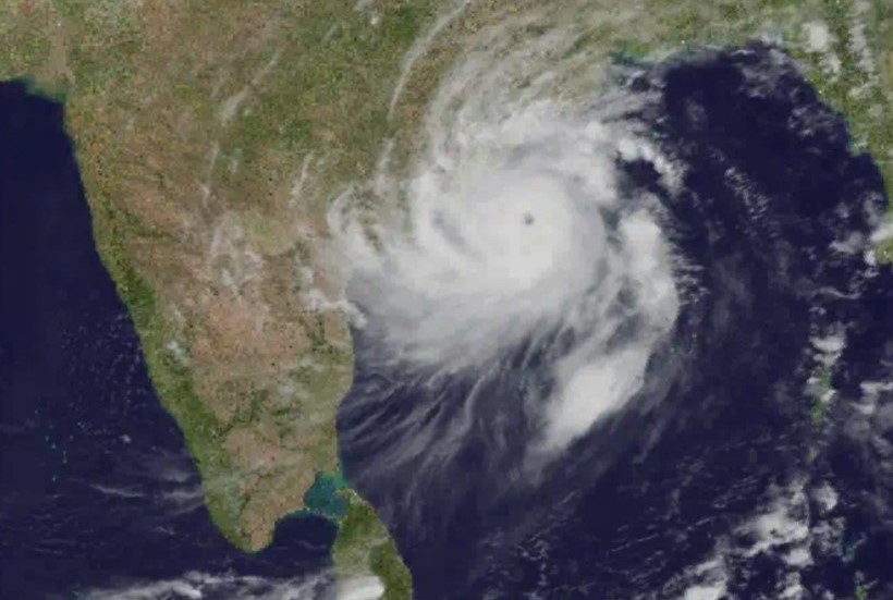
The eye of Cyclone Fani, which struck Odisha on May 3 causing large scale destruction across 14 districts, passed through Bhubaneswar with sustained wind speed between 169 and 189 km per hour, said researchers from IIT Bhubaneswar.
“The forecast at 11:30 am indicates that Cyclone Fani was close to Bhubaneswar in between Bhubaneswar and IIT Bhubaneswar with a sustained wind of 189 km per hour in Bhubaneswar. This clearly illustrates that the eye of the cyclone passed through south Bhubaneswar and north of IIT Bhubaneswar with the latter in the eye wall sector, which is one of the potential damage zone,” a statement by the researchers of IIT Bhubaneswar said.
The researchers said the observations available from IIT Bhubaneswar observatory and ITER, SoA (deemed to be university) observatory were in good agreement with the model predicted movement of the ‘extremely severe cyclonic storm’ and its intensity. IIT observatory has recorded a maximum sustained wind of 169 km per hour with gust factor of about ±20 km per hour. In agreement with model, the campus received very heavy rainfall of about 16 cm on the day of landfall.
A team of weather researchers headed by Prof. U.C. Mohanty and Prof. Sandeep Kumar Pattnaik, School of Earth, Ocean and Climate Sciences (SEOCS), IIT Bhubaneswar also predicted the course of the cyclone using their high-resolution meso scale models. “The forecast at 10:30 to 11:30 am indicates that the cyclone was close to Bhubaneswar in between Bhubaneswar and IIT Bhubaneswar with a sustained wind of 169 km per hour, with gust factor of ±20 km per hour going up to 190 km/hr as measured,” the statement said.
As a result, no two peaks were observed but a long drawn single peak with direction changing from north to west as experienced by campsites. This indicates, according to the researchers, that eye of Cyclone Fani is passed from the eastern side of the campus.
The forecast and observations of IIT Bhubaneswar are well reflected in destructive potential to infrastructure and the green cover over the city of Puri, Khurda, Bhubaneswar and Cuttack and also the peripheral towns and villages. Owing to the severity, the cyclone uprooted thousands of trees of the green campus including the state of the art infrastructure, according to Prof. R.V. Raja Kumar, director, IIT Bhubaneswar.
The faculty and research scientists of School of Earth Ocean and Climate Sciences, IIT Bhubaneswar has predicted the course of movement, intensity and associated storm surge of Cyclone Fani with great degree of accuracy well in advance prior to five days before its landfall at Puri with a state of the art meso-scale modelling systems. The model known as Hurricane Weather Research and Forecast model (HWRF) is customised specifically for cyclone forecast over Bay of Bengal and Arabian Sea in a close collaboration among Hurricane Research Division (HRD), National Oceanic and Atmospheric Administration (NOAA), USA, India Meteorological Department (IMD), New Delhi, IIT Bhubaneswar and Indian National Centre for Oceanic Information System (INCOIS), Hyderabad.
The same model is being run concurrently at IMD, New Delhi on operational basis and IIT Bhubaneswar in R&D mode for real time prediction of cyclones with different source of initial conditions. The experimental products generated during the real time forecast of cyclones by IIT Bhubaneswar are disseminated to IMD, New Delhi for their operational use.