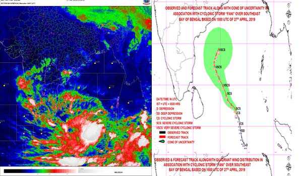
The Cyclonic Storm ‘FANI’ (pronounced as ‘FONI’) over southeast Bay of Bengal and neighbourhood moved north-northwestwards with a speed of about 13 kmph in the last six hours and lay centred at 0530 hrs on Sunday near latitude 7.3°North and longitude 87.9°East over southeast Bay of Bengal & neighbourhood, about 745 km east-southeast of Trincomalee (Sri Lanka), 1050 km southeast of Chennai (Tamil Nadu) and 1230 km south-southeast of Machilipatnam (Andhra Pradesh).
India Meteorological Department (IMD) in a bulletin said It is very likely to intensify into a ‘Severe Cyclonic Storm’ during next 12 hours and into a ‘Very Severe Cyclonic Storm’ during subsequent 24 hours.
The very severe cyclonic storm is very likely to move northwestwards till May 1 and thereafter recurve northeastwards gradually.
Heavy rainfall warning:
Light to moderate rainfall at many places with heavy falls at isolated places is very likely over Kerala on April 29 and 30. Light to moderate rainfall at few places over North Coastal Tamil Nadu and Coastal Andhra Pradesh on April 29 and 30.
Wind warning:
Gale wind speed reaching 80-90 kmph gusting to 100 kmph is prevailing over Southeast Bay of Bengal and neighbourhood. It is very likely to become 90-100 kmph gusting to 115 kmph from this evening over the same area; 120-130 kmph gusting to 145 kmph over Southwest Bay of Bengal from April 30 morning and 155-165 kmph gusting to 175 kmph over southwest and adjoining westcentral Bay of Bengal off north Tamil Nadu, Puducherry and South Andhra Pradesh Coasts from May 1 evening. It is likely to decrease gradually thereafter with gale wind speed reaching 130-140 kmph gusting to 150 kmph over westcentral Bay of Bengal off Andhra Pradesh Coast on May 3.
Strong wind speed reaching 30-40 kmph gusting to 50 kmph likely to commence along and off Tamil Nadu and Puducherry Coast, Comorin area and Gulf of Mannar from today, becoming squally wind speed reaching 40-50 kmph gusting to 60 kmph from the morning of Monday.
It is very likely to become squally wind speed reaching 50-60 kmph gusting to 70 kmph from the morning of April 30 along north Tamil Nadu, Puducherry and south Andhra Pradesh Coasts.
Strong wind speed reaching 30-40 kmph gusting to 50 kmph likely to commence along and off Kerala coast from this evening and becoming squally wind speed reaching 40-50 kmph gusting to 60 kmph on April 29 and 30.
Sea condition :
The sea condition is very high over Southeast Bay of Bengal and neighbourhood. It is very likely to become very high to phenomenal over Southwest Bay of Bengal from the morning tomorrow and phenomenal over southwest and adjoining westcentral Bay of Bengal, off North Tamil Nadu, Puducherry and South Andhra Pradesh Coasts from the night of May 30.
Sea conditions very likely to be rough to very rough along and off Puducherry, Tamil Nadu and south Andhra Pradesh Coasts from April 29 to May 1 and westcentral Bay of Bengal off Andhra Pradesh Coast on May 2.
Fishermen Warning:
The fishermen are advised not to venture into deep sea areas of Southeast Bay of Bengal and adjoining Equatorial Indian Ocean, over Southwest Bay of Bengal and off Sri Lanka coast today; Southwest & adjoining westcentral Bay of Bengal, along & off Sri Lanka, Puducherry, Tamil Nadu & south Andhra Pradesh coasts from April 29 to May 1 and westcentral Bay of Bengal off Andhra Pradesh Coast on May 2.
Those, who are out in deep sea areas are advised return to the coast by today, IMD said.